At what temperature does the White Sea freeze. At what temperature does water freeze
Sea water freezes at temperatures below zero degrees. The higher the salinity of sea water, the lower its freezing point. This can be seen from the following table:
| Salinity in °/00 |
Freezing point |
Salinity in °/00 | Freezing point (in degrees) |
| 0 (fresh water) | 0 | 20 | -1,1 |
| 2 | -0,1 | 22 | -1,2 |
| 4 | -0,2 | 24 | -1,3 |
| 6 | -0,3 | 26 | -1,4 |
| 8 | -0,4 | 28 | -1,5 |
| 10 | -0,5 | 30 | -1,6 |
| 12 | -0,6 | 32 | -1,7 |
| 14 | -0,8 | 35 | -1,9 |
| 16 | -0,9 | 37 | -2,0 |
| 18 | -1,0 | 39 | -2,1 |
This table shows that a 2°/00 increase in salinity lowers the freezing point by approximately one tenth of a degree.
In order to start freezing water with an oceanic salinity of 35 ° / 00, it must be cooled below zero by almost two degrees.
Falling on unfrozen fresh river water, ordinary snow with a melting point of zero degrees, as a rule, melts. If this very snow falls on unfrozen sea water with a temperature of -1 °, then it does not melt.
Knowing the salinity of the water, you can determine the freezing point of any sea using the table above.
Salinity of water Sea of Azov in winter about 12 ° / 00; consequently, water begins to freeze only at a temperature of 0°.6 below zero.
In the open part of the White Sea, salinity reaches 25 ° / 00. This means that for freezing, water must cool below minus 1 °.4.
Water with a salinity of 100 ° / 00 (such salinity can be found in the Sivash, separated from the Sea of \u200b\u200bAzov by the Arabat Spit) will freeze at a temperature of minus 6 °. when its temperature falls well below 10°C!
When salty sea water is cooled to the appropriate freezing point, primary ice crystals begin to appear in it, shaped like very thin hexagonal needle-like prisms.
Therefore, they are usually called ice needles. Primary ice crystals that form in salty sea water do not contain salt; it remains in solution, increasing its salinity. This is easy to verify. Having collected ice needles with a net of very thin gauze or tulle, you need to rinse them with fresh water to wash off the salt water, and then melt them in another dish. Get fresh water.
Ice, as you know, is lighter than water, so ice needles float. Their accumulations on the surface of the water resemble appearance spots of fat on the cold soup. These accumulations are called fat.
If the frost intensifies and the surface of the sea quickly loses heat, then the fat begins to freeze, and in calm weather, an even, smooth, transparent ice crust appears, which the Pomors, the inhabitants of our northern coast, call nilas. It is so pure and transparent that in huts made of snow, it can be used instead of glass (of course, if there is no heating inside such a hut). If you melt the nilas, the water will turn out to be salty. True, its salinity will be lower than the water from which the ice needles were formed.

Separate ice needles do not contain salt, and salt appears in the sea ice formed from them. This is because the randomly located ice needles, freezing, capture the smallest droplets of salty sea water. Thus, in sea ice, salt is distributed unevenly - in separate inclusions.
Salinity sea ice depends on the temperature at which it was formed. With a slight frost, ice needles freeze slowly and capture little salt water. In severe frost, ice needles freeze much faster and capture a lot of salt water. In this case, the sea ice will be more salty.
When sea ice begins to melt, salt inclusions are first thawed out of it. Therefore, the old, multi-year polar ice, which has “flyed over” several times, becomes fresh. Polar winterers usually use snow for drinking water, and when it is not available, then old sea ice.
If during education ice is coming snow, then it, without melting, remains on the surface of sea water, is saturated with it and, freezing, forms muddy, whitish, opaque uneven ice - young. Both nilas and juveniles are broken into pieces by wind and excitement, which, colliding with each other, round the corners and gradually turn into round ice floes - pancakes. When the excitement weakens, pancakes freeze, forming solid pancake ice.
Near the coast, on the shallows, sea water cools faster, so ice appears earlier than in the open sea. Usually ice freezes to the shores, this is fast ice. If frosts are accompanied by calm weather, fast ice grows rapidly, sometimes reaching a width of many tens of kilometers. But strong winds and waves break the fast ice. Parts torn off from it float away with the flow, are carried away by the wind. This is how floating ice is formed. They have different names depending on their size.

An ice field refers to floating ice with an area of more than one square nautical mile.
Fragments of an ice field are called floating ice with a length of more than one cable length.
Coarsely broken ice is shorter than one cable length, but more than one tenth of a cable length (18.5 m). Finely broken ice does not exceed one tenth of a cable, and ice porridge consists of small pieces tumbling on the waves.
Currents and wind can push ice floes against fast ice or against each other. The pressure of the ice fields on each other causes the crushing of floating ice. This usually creates heaps of finely broken ice.
When a single ice floe rears up and in this position freezes into the surrounding ice, it forms a ropak. Ropaki, covered with snow, are poorly visible from an aircraft and can cause a disaster during landing.
Often, under the pressure of ice fields, ice shafts are formed - hummocks. Sometimes hummocks reach a height of several tens of meters. Hummocked ice is difficult to pass, especially for dog teams. It is a serious obstacle even for powerful icebreakers.

A fragment of a hummock that rises above the surface of the water and is easily carried away by the wind is called a nesyak. Nesyak, stranded, is called stamukha.
Around Antarctica and in the Arctic Ocean there are ice mountains - icebergs. These are usually fragments of continental ice.
In Antarctica, as researchers have recently established, icebergs also form in the sea, on the continental shelf. Only part of the iceberg is visible above the surface of the water. Most of its share (about 7/8) is under water. The area of the underwater part of the iceberg is always much larger than the surface. Therefore, icebergs are dangerous for ships.
Now icebergs are easily detected in the distance and in the fog by means of precise radio devices on the ship. Earlier there were cases of collisions of ships with icebergs. So, for example, in 1912 the huge ocean passenger steamer Titanic perished.
THE WATER CYCLE IN THE WORLD OCEAN
In the polar regions, the water, cooling down, becomes denser and sinks to the bottom. From there, it slowly slides towards the equator. Therefore, at all latitudes, deep waters are cold. Even at the equator, the bottom waters have a temperature of only 1-2 ° above zero.
Since currents carry warm water from the equator to temperate latitudes, it rises very slowly from the depths to its place. cold water. On the surface, it warms up again, goes to the subpolar zones, where it cools down, sinks to the bottom and again moves along the bottom to the equator.
Thus, in the oceans there is a kind of water cycle: on the surface, water moves from the equator to the subpolar zones and along the bottom of the oceans - from the subpolar zones to the equator. This process of water mixing, along with other phenomena mentioned above, creates the unity of the oceans.
Experiments with ice for children are always interesting. Conducting experiments with Vlad, I even made several discoveries for myself.
Today we will find answers to next questions:
- How does water behave when frozen?
- What happens if you freeze salt water?
- coat will warm the ice?
- and some others...
freezing water
 Water expands when it freezes. The photo shows a glass of frozen water. It can be seen that the ice has risen in a tubercle. Water does not freeze evenly. At first, ice appears at the walls of the glass, gradually filling the entire vessel. In water, the molecules move randomly, so it takes the shape of the vessel in which it is poured. Ice, on the other hand, has a clear crystalline structure, while the distances between ice molecules are greater than between water molecules, so ice takes up more space than water, that is, it expands.
Does salt water freeze?
The more salty the water, the lower the freezing point. For the experiment, we took two glasses - in one fresh water (marked with the letter B), in the other very salty water (marked with the letters B + C). 
After standing in the freezer all night, the salt water did not freeze, but ice crystals formed in the glass. Fresh water turned to ice. While I was manipulating cups and salt solutions, Vladik created his own unplanned experiment.
Poured water into a mug vegetable oil and quietly placed in the freezer.  The next day, I found a mug of ice and cloudy oil floating. We conclude that different liquids have different freezing temperatures.
Salt water in the freezer did not freeze, but what happens if you sprinkle salt on the ice? Let's check.
Experience with ice and salt
Take two ice cubes. Sprinkle one of them with salt, and leave the second for comparison.  Salt corrodes the ice, making grooves and passages in the ice cube. As expected, the ice cube sprinkled with salt melted much faster. That is why the janitors sprinkle the paths with salt in winter. If you sprinkle salt on ice, you can not only watch the melting, but also draw a little!
We froze a big icicle and sprinkled it with salt, took brushes and  watercolor paints and began to create beauty. The eldest son applied paint to the ice with a brush, and the younger one with his hands.
Our experienced creativity unites the whole family, so Makarushkin's pen got into the camera lens!
Makar and Vlad are very everyone loves to freeze . Sometimes there are completely unexpected items in the freezer.
I dreamed of doing this experience since childhood, but my mother did not have a fur coat, and many  I didn’t need a fur coat and no substitutes! My beloved bought me a fur coat, and now I present to your attention this wonderful experience. At the beginning, I had no idea how you could decide to wrap ice cream in a fur coat, even if you really want to experiment. And if the experiment fails, how to wash it later. Oh, it was not! ..
 I put ice cream in bags :) I wrapped it in a fur coat and waited. Wow, everything is great! The fur coat is intact, and the ice cream has melted much less than the control sample, standing nearby without a fur coat.
How great it is to be an adult, to have a fur coat and do all sorts of children's experiments!
Children love to color and decorate. And colored ice delivers a lot of positive emotions and allows you to develop creativity in kids. The experiments are not only bright, informative, but also useful. I give you recipes for even more bright experiments for children now. Download a useful collection of experiments for your home laboratory - "Experiments with water". Write in the comments your feedback about the experiments and wishes: what experiences would you like to see on the pages of our site. Science is fun.
Your Galina Kuzmina
Water in the seas and oceans is very different from river and lake water. It is salty - and this determines many of its properties. The freezing point of sea water also depends on this factor. It does not equal 0 °C, as is the case with fresh water. To be covered with ice, the sea needs a stronger frost.
It is impossible to say unequivocally at what temperature sea water freezes, since this indicator depends on the degree of its salinity. In different places of the world ocean it is different.
The most salty is the Red Sea. Here the concentration of salt in the water reaches 41‰ (ppm). The least amount of salt in the waters of the Baltic Gulf is 5‰. In the Black Sea, this figure is 18‰, and in the Mediterranean - 26‰. The salinity of the Sea of Azov is 12‰. And if we take the average, the salinity of the seas is 34.7‰.
The higher the salinity, the more the sea water must cool to become solid.
This is clearly seen from the table:
| Salinity, ‰ | Freezing point, °C | Salinity, ‰ | Freezing point, °C |
|---|---|---|---|
| 0 (fresh water) | 20 | -1,1 | |
| 2 | -0,1 | 22 | -1,2 |
| 4 | -0,2 | 24 | -1,3 |
| 6 | -0,3 | 26 | -1,4 |
| 8 | -0,4 | 28 | -1,5 |
| 10 | -0,5 | 30 | -1,6 |
| 12 | -0,6 | 32 | -1,7 |
| 14 | -0,8 | 35 | -1,9 |
| 16 | -0,9 | 37 | -2,0 |
| 18 | -1,0 | 39 | -2,1 |
Where the salinity is even higher, as, for example, in Lake Sivash (100 ‰), Kara-Bogaz-Gol Bay (250 ‰), in the Dead Sea (over 270 ‰), water can freeze only with a very large minus - in the first case - at -6.1 °C, in the second - below -10 °C.
For the average indicator for all seas, -1.9 ° C can be taken.
Freezing stages
It is very interesting to watch how sea water freezes. It is not immediately covered with a uniform ice crust, like fresh water. When part of it turns into ice (and it is fresh), the rest of the volume becomes even more salty, and an even stronger frost is required to freeze it.
Ice types
As the sea cools, different types of ice form:
- snowstorm;
- sludge;
- needles;
- Salo;
- nilas.
If the sea has not yet frozen, but is very close to it, and at that time snow falls, it does not melt when it comes into contact with the surface, but is saturated with water and forms a viscous mushy mass called snow. Freezing, this porridge turns into sludge, which is very dangerous for ships caught in a storm. Because of it, the deck is instantly covered with an ice crust.
When the thermometer reaches the mark necessary for freezing, ice needles begin to form in the sea - crystals in the form of very thin hexagonal prisms. Collecting them with a net, washing off the salt and melting them, you will find that they are insipid.
First, the needles grow horizontally, then they take a vertical position, and only their bases are visible on the surface. They resemble spots of fat in a cold soup. Therefore, ice at this stage is called lard.
When it gets even colder, the fat begins to freeze and forms an ice crust, as transparent and fragile as glass. Such ice is called nilas, or bottle. It is salty, although it is formed from unleavened needles. The fact is that during freezing, the needles capture the smallest drops of the surrounding salt water.
Only in the seas is there such a phenomenon as floating ice. It arises because the water here cools faster off the coast. The ice formed there freezes to the coastal edge, which is why it was called fast ice. As frost intensifies during calm weather, it quickly captures new territories, sometimes reaching tens of kilometers in width. But as soon as a strong wind rises, the fast ice begins to break into pieces of various sizes. These ice floes, often huge (ice fields), are carried by the wind and current throughout the sea, causing problems for ships.
Melting temperature
Sea ice does not melt at the same temperature at which sea water freezes, as one might think. It is less salty (on average 4 times), so its transformation back into liquid begins earlier than reaching this mark. If the average freezing point of sea water is -1.9 °C, then the average melting temperature of the ice formed from it is -2.3 °C.
Salt Water Freezing: Video
The table shows the thermophysical properties of a solution of calcium chloride CaCl 2 depending on temperature and salt concentration: specific heat of the solution, thermal conductivity, viscosity of aqueous solutions, their thermal diffusivity and the Prandtl number. The concentration of salt CaCl 2 in solution is from 9.4 to 29.9%. The temperature at which the properties are given is determined by the salt content of the solution and ranges from -55 to 20°C.
calcium chloride CaCl 2 may not freeze up to minus 55°С. To achieve this effect, the salt concentration in the solution should be 29.9%, and its density will be 1286 kg/m 3 .
With an increase in the salt concentration in a solution, not only its density increases, but also such thermophysical properties as the dynamic and kinematic viscosity of aqueous solutions, as well as the Prandtl number. For example, dynamic viscosity of CaCl 2 solution with a salt concentration of 9.4% at a temperature of 20°C is 0.001236 Pa s, and with an increase in the concentration of calcium chloride in the solution to 30%, its dynamic viscosity increases to a value of 0.003511 Pa s.
It should be noted that the temperature has the strongest influence on the viscosity of aqueous solutions of this salt. When a solution of calcium chloride is cooled from 20 to -55°C, its dynamic viscosity can increase by 18 times, and kinematic by 25 times.
Given the following thermophysical properties of CaCl 2 solution:
- , kg / m 3;
- freezing point °С;
- dynamic viscosity of aqueous solutions, Pa s;
- Prandtl number.
The density of a solution of calcium chloride CaCl 2 depending on temperature
The table shows the values of the density of a solution of calcium chloride CaCl 2 of various concentrations depending on the temperature.
The concentration of calcium chloride CaCl 2 in solution is from 15 to 30% at a temperature of -30 to 15°C. The density of an aqueous solution of calcium chloride increases with a decrease in the temperature of the solution and an increase in the salt concentration in it.
Thermal conductivity of CaCl 2 solution depending on temperature
The table shows the thermal conductivity of a solution of calcium chloride CaCl 2 of various concentrations at low temperatures.
The concentration of CaCl 2 salt in solution is from 0.1 to 37.3% at a temperature of -20 to 0°C. As the concentration of salt in the solution increases, its thermal conductivity decreases.
Heat capacity of CaCl 2 solution at 0°С
The table shows the values of the mass heat capacity of a solution of calcium chloride CaCl 2 of various concentrations at 0°C. The concentration of salt CaCl 2 in solution is from 0.1 to 37.3%. It should be noted that with an increase in the concentration of salt in a solution, its heat capacity decreases.
Freezing point of solutions of NaCl and CaCl 2 salts
The table shows the freezing point of solutions of salts of sodium chloride NaCl and calcium CaCl 2 depending on the salt concentration. The salt concentration in the solution is from 0.1 to 37.3%. Freezing point saline solution determined by salt concentration in solution and for sodium chloride NaCl can reach a value of minus 21.2°C for a eutectic solution.
It should be noted that sodium chloride solution may not freeze to a temperature of minus 21.2 ° C, and a solution of calcium chloride does not freeze at temperatures up to minus 55°С.
Density of NaCl solution as a function of temperature
The table shows the values of the density of a solution of sodium chloride NaCl of various concentrations depending on temperature.
The concentration of the NaCl salt in the solution is from 10 to 25%. The density values of the solution are indicated at temperatures from -15 to 15°C.
Thermal conductivity of NaCl solution as a function of temperature
The table shows the thermal conductivity values of a solution of sodium chloride NaCl of various concentrations at negative temperatures.
The concentration of the NaCl salt in the solution is from 0.1 to 26.3% at a temperature of -15 to 0°C. According to the table, it can be seen that the thermal conductivity of an aqueous solution of sodium chloride decreases as the concentration of salt in the solution increases.
Specific heat capacity of NaCl solution at 0°С
The table shows the values of the mass specific heat of an aqueous solution of sodium chloride NaCl of various concentrations at 0°C. The concentration of the NaCl salt in the solution is from 0.1 to 26.3%. According to the table, it can be seen that with an increase in the concentration of salt in a solution, its heat capacity decreases.
Thermophysical properties of NaCl solution
The table shows the thermophysical properties of a solution of sodium chloride NaCl depending on temperature and salt concentration. The concentration of sodium chloride NaCl in solution is from 7 to 23.1%. It should be noted that when an aqueous solution of sodium chloride is cooled, its specific heat capacity changes slightly, the thermal conductivity decreases, and the viscosity of the solution increases.
Given the following thermophysical properties of NaCl solution:
- solution density, kg/m 3 ;
- freezing point °С;
- specific (mass) heat capacity, kJ/(kg deg);
- thermal conductivity coefficient, W/(m deg);
- dynamic viscosity of the solution, Pa s;
- kinematic viscosity of the solution, m 2 /s;
- thermal diffusivity, m 2 /s;
- Prandtl number.
The density of solutions of sodium chloride NaCl and calcium CaCl 2 depending on the concentration at 15 ° C
The table shows the density values of solutions of sodium chloride NaCl and calcium CaCl 2 depending on the concentration. The concentration of the NaCl salt in the solution is from 0.1 to 26.3% at a solution temperature of 15°C. The concentration of calcium chloride CaCl 2 in the solution is in the range from 0.1 to 37.3% at its temperature of 15°C. The density of solutions of sodium chloride and calcium increases with increasing salt content.
Volumetric expansion coefficient of solutions of sodium chloride NaCl and calcium CaCl 2
The table shows the values of the average coefficient of volumetric expansion of aqueous solutions of sodium chloride NaCl and calcium CaCl 2 depending on the concentration and temperature.
The volume expansion coefficient of the NaCl salt solution is indicated at a temperature of -20 to 20°C.
The volumetric expansion coefficient of the CaCl 2 chloride solution is given at -30 to 20°C.
Sources:
- Danilova G. N. et al. Collection of tasks on heat transfer processes in the food and refrigeration industry. M.: Food industry, 1976.- 240 p.
Salts dissolved in sea water. Many different salts are dissolved in the cloudy water, which give it a peculiar bitter-salty taste. The salty taste of sea water is mainly due to a solution of sodium chloride (common salt). The bitter taste depends on solutions of magnesium salts (MgCl 2 , MgSO 4 ). 1 thousand G(liter) ocean water contains an average of 27.2 G sodium chloride, 3.8 G magnesium chloride, 1.7 G magnesium sulfate. Next come calcium sulfate (CaSO 4 ) 1,2 G, potassium sulfate (K 2 SO 4 ) 0,9 G and others, the content of which does not exceed 0.1 G. Thus, for 1 thousand G ocean water accounts for 35 G salts.
No matter how sea water is diluted with fresh water, the percentage of salts that make up its composition remains strictly constant.
So:
In addition, the composition of sea water includes up to 30 different substances, but their number is so small that all of them together make up no more than 0.1%.
The water of the oceans and seas, as already mentioned, is in a continuous cycle. It evaporates, falls as precipitation, travels long distances through underground and surface waters, and returns to the ocean again. Passing these long paths, water dissolves many different substances and brings them into the oceans. Thus, the World Ocean is, as it were, a place of accumulation of those soluble substances that are constantly brought there by rivers and rivers. However, if we compare chemical composition solutions contained in sea and fresh water, we will notice a big difference.
In sea water, chloride salts predominate, while in river water, on the contrary, there are very few of them. In river water there are a lot of carbonic salts (calcium carbonate), while in sea water there are very few of them. The latter is explained by the fact that calcium carbonate, silicon and other substances in the seas are consumed in large quantities by animal and plant organisms to create all kinds of skeletal formations, shells, coral structures, etc. After the death of these organisms, their skeletons and shells fall to the bottom, forming huge strata of sediments there. In general, it should be noted that the ratio of salts in sea water is constantly regulated by the organic life of the sea.
Salinity. For 1 l ( 1 thousand G) cloudy water, as already mentioned, on average there are about 35 G salts. In other words: for 1 thousand weight parts of cloudy water there are 35 weight parts of salts. The number 35 in this case means salinity sea water, expressed in thousandths. Symbolically, salinity is indicated as follows: S\u003d 35 ° / oo, i.e. salinity (S) = 35 ppm.
The water of the oceans, taken far from the coast, usually has a salinity (S)=35°/oo. The water of the coastal parts, desalinated by rivers, has a salinity of 34-33 and even 32% o. In zones of trade winds, where rains are rare and evaporation is high, salinity rises to 36 and even 37% o.
In the Arctic Ocean, on the contrary, due to low evaporation, the salinity on the surface drops to 34% o. Reduced salinity is also observed in the equatorial zone, where a lot of precipitation falls (Fig. 157).
At depths over 1000-1500 m salinity in all oceans 35% 0 .
The situation with the seas is somewhat different. The marginal seas, connected to the oceans by a wide strait or a large number of straits, have a rather high salinity. So, for example, in the Sea of Japan it is expressed in ZZ 0/00 in the Sea of Okhotsk - 32°/oo. The inland seas, remote from the oceans, into which many large rivers flow, have low salinity. So, for example, the salinity of the Black Sea is 14-19 ° / O o, the Baltic 8-12% 0, and in the northern part of the Gulf of Bothnia even 3 ° / 00. Conversely, seas surrounded by areas with a dry climate have increased salinity. So, the Mediterranean Sea has a salinity of 38-39 ° / oo, and the Red Sea, surrounded by deserts, has a salinity of about 41% 0.
The study of salinity has great importance both in science and in practical life. Accurate knowledge of salinity makes it possible to determine the currents and, in general, the movement of water masses both in the horizontal and vertical directions. The salinity and specific gravity of sea waters are of great importance in defense matters. Submarine navigation, depth and speed of submergence, mining of waters, torpedoing of enemy ships, etc. require accurate knowledge of salinity and currents in one or another part of the sea.
Color. Clear window glass appears completely transparent to us. But if you put two or three dozen clean transparent glasses in a stack, it turns out that the stack of glasses has become translucent and hardly transmits blue or slightly greenish light. This means that pure transparent glass is still not completely transparent and not colorless.
Approximately the same has to be said about water. Pure distilled water appears colorless and completely transparent. However, this is observed only if the water layer is relatively thin. In a thicker layer, the water appears bluish. This bluish color is easy to spot in a white tub filled with clean, clear water.
For exact definition colors of pure water took a glass tube at 5 m length and, filling it with distilled water, closed both ends of the tube with flat glasses. The tube was placed in an opaque case. Having installed one end of the tube in the window, they looked at the other end into the light. It turned out that pure distilled water has a wonderful delicate and pure blue color. This means that water absorbs the red and yellow rays of the spectrum and transmits the blue well.

Knowing that pure water has a blue color, we can easily understand why the pure water of lakes, seas and oceans has a predominantly blue color. Any admixture to water changes color. So, for example, if you add the finest powder of yellow or reddish color to pure water, then the water acquires a greenish tint, etc. The latter is clearly visible on the sea near the coast after strong surfs: the turbulent water near the coast acquires a greenish color.
Salts dissolved in sea water do not affect the color of the water, which is why the water of the seas has a predominantly blue color. However, impurities of suspended particles of silt immediately give the water one or another shade. So, for example, r. The Huang He (Yellow), flowing through the loess regions of China, colors the sea water yellowish (Yellow Sea). The admixture of silt particles brought by rivers gives the water of the White Sea a greenish color, and the waters of the Baltic Sea - a muddy green tint.
Transparency. Impurities of various substances not only change color, but also change the degree of transparency of water. Everyone knows that turbid waters are the least transparent, and pure water is the most transparent. In science and in practical life (especially in defense), the study of the color and transparency of water is of great importance. To study the degree of transparency of water, a very simple device is used - the Secchi disk. It consists of a zinc disk having 30 cm in diameter, painted White color. The disk, like a cup of ordinary scales, is hung from a cord and slowly immersed in water. At the same time, they monitor from above at what depth the white disk ceases to be visible. This depth determines the degree of transparency of the water in the pool. So, for example, in the White Sea, the disk becomes invisible at a depth of 6-8 m, in the Baltic 11 -13 m, in Black 28 m. The waters of the Mediterranean Sea are the most transparent - up to 50-60 m. The waters are also very transparent. Pacific Ocean (59 m) and especially the Sargasso Sea (66 m).
When determining transparency, color is usually also determined. The white disc changes color as you dive. In some basins, the disk takes on a blue color at a certain depth, in others green, etc.
To accurately indicate the observed color, a scale is used, consisting of a number of tubes filled with solutions of various shades from blue to yellow.
The glow of the sea. At night, the glow of sea water is often observed. The latter does not come from the water itself, but from some organisms that live in sea water, capable of emitting light. These organisms include: luminous bacteria, unicellular (especially nocturnal, which in in large numbers appear at the end of summer), some jellyfish, etc.
Sea water temperature. Water is the warmest body on earth. To heat up 1 cm 3 water by 1 0, you need to spend as much heat as it takes to heat it 5 cm 3 on the same 1° granite or 3134 cm 3 air. This means that the heat capacity of water is five times that of granite and more than 3,000 times that of air.
The surface of the oceans and seas is more than 2/3 of the surface the globe. Therefore, more than 2/3 of the solar energy absorbed by the surface of the globe falls on the oceans. Part of this heat is spent on evaporation, part on heating the air above the sea, part, being reflected, is radiated into the heavenly space and part is used to heat the water surface itself. As a result, according to rough estimates, out of the total amount of solar heat falling on a unit surface of a water basin, 60% is spent on heating in the tropical zone, about 30% in temperate zones, and up to 10% in cold ones.
We have already noted the role of this heat in the life of the atmosphere and the life of continental waters. It was also said that the daily and annual fluctuations in the temperature of the water surface are completely different compared to
with dry. Let us only recall that the daily amplitude of the ocean surface in the tropical zone is expressed as 0.5-1°, in the temperate zone about 0.4°, and in the cold zone about 0.1°. As for the annual amplitude, it is also very small: in the hot zone 2-3°, in the temperate zone from 5 to 10° and in the cold 1-2°. Having noted these features in the heating of the water surface, we now turn to the temperatures of the oceans and seas.
Measurement of temperatures of the seas and oceans. Measuring the temperature of the surface layers presents no difficulties. They take a bucket of water, lower a thermometer into the bucket, which will show the temperature. As for the deeper layers of water, and in particular the measurement of temperature at depths, here it is necessary to use thermometers of a very special device, called deep thermometers(Fig. 158).
A deep thermometer must first of all withstand the force of that enormous pressure that exists at depths. This is achieved, firstly, by enclosing the thermometer in a tube of thick glass, and then in a copper sleeve so that the water touches the thick-walled glass tube of the thermometer only near the mercury ball. In addition, a deep thermometer must record the temperature that is marked by it at depth. The latter is achieved by the fact that at the right moment, according to a signal given from above, the thermometer quickly turns upside down. In this case, the mercury column in the thermometer breaks, which makes it possible to fix the thermometer reading.
Surface temperature of the oceans and seas. shipLi, which swim in various seas and oceans, daily, along with the determination of geographical coordinates, determine the temperature of the water on the surface of the sea. Based on such numerous observations, maps of the average monthly and annual temperatures of the surface of the World Ocean are compiled and the corresponding isotherms are plotted (Fig. 159). The isotherm maps show that the surface temperature of the oceans in the hot zone rises to the west, and in the temperate zone to the east. The latter depends, as we shall see later, on sea currents, which in the tropical zone are directed mainly to the west, and in the temperate zone deviate to the east.
Comparing the same average annual air temperatures over land and over the oceans, we see that in the hot zone the average annual temperature on land is somewhat higher than over the sea. In the temperate and cold zones, on the contrary, the temperature over the sea is much higher than over land. We have already noted this moderating and warming influence of the sea.
Temperatures at depths. Direct measurements showed that diurnal fluctuations, although very insignificant, can be seen to a depth of 25-30 m, annual up to 200-300 m, and in some cases even up to 350 m. Deeper than 300-350 m the temperature remains the same in all seasons. In other words, at a depth of 300-350 m we have a layer of constant temperature. However, with depth, the temperature continues to gradually decrease (for every 1,000 km). m depth by approximately 1-2 °), and at a depth of 3-4 thousand meters. m it reaches 2° and even up to -1°. This

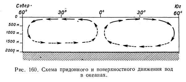
the gradual decrease in temperature with depth is explained by the fact that cold water, having a high density, sinks down, and warm water, being lighter, is concentrated in the upper layers. Unlike fresh water, sea water acquires its highest density not at 4°C, but at 2°C and below, which again depends on the degree of its salinity. The low temperature of the depths of all oceans is explained by the influence of the polar seas and oceans. There, the water, cooling down to - 1 and - 2 °, descends and slowly spreads along the bottom of all oceans. True, there is a very slow, but constant movement of water in the near-bottom parts from the poles to the equator and in the upper parts from the equator to the poles (Fig. 160). The presence of such a movement makes it clear why the bottom temperatures southern parts oceans below the same bottom temperatures of the northern parts of the oceans. The underwater threshold (Thomson) in the Atlantic Ocean blocks the way to the bottom cold waters of the Arctic Ocean, due to which in the northern part Atlantic Ocean the bottom temperature is 3°.5 and 4°, and beyond the Thomson threshold, in the Arctic Ocean, it immediately drops to -1.2°.
The absence of such thresholds in the South Atlantic is counterproductive. There already from 50 ° S. sh. bottom temperature is below 0°.
The northern part of the Pacific Ocean is even more sharply separated from the Arctic Ocean, which leads to a decrease in temperatures towards the south.
Freezing sea water. The freezing process of sea water is much more complicated than that of fresh water. Fresh water under normal conditions freezes at 0°C, while sea water freezes at lower temperatures. The freezing point of sea water depends primarily on the degree of its salinity, which can be clearly seen from the table below:

Fresh water has its highest density at 4°C. As for sea water, it reaches its greatest density at lower temperatures, again depending on the degree of salinity. For example:
The water of freshwater pools, when cooled from the surface, becomes heavier and sinks down, and lighter warm water rises in its place from the depths. This kind of movement (called convection) gradually captures larger and larger thicknesses of water. When, finally, the entire mass of water is cooled to 4 ° C, i.e., reaches its maximum density, convection stops, because the water on the surface of the pool, cooling further, becomes lighter. Under these conditions, the surface layer further cools very rapidly and soon freezes. In sea water, convection does not stop, because the density of water increases with decreasing temperature. In addition, when sea water freezes, ice crystals are formed from clean (fresh) water, and salt is released and increases the salinity of unfrozen water. With an increase in salinity, the freezing point and the temperature of the highest density, as can be seen from the tables above, decrease significantly. All this taken together greatly slows down the freezing process. Thus, freezing of sea water requires lower temperatures and a longer duration of time. Abundant snowfall (desalinating the surface of sea water) accelerates freezing. Excitement, on the contrary, slows down freezing.
Freezing fresh water we distinguished three moments: the formation of fat, the formation of pancake ice, and, finally, the complete freezing of the entire surface. The freezing of the sea proceeds in approximately the same way. Crystals in sea water are formed larger and coalesce into larger lumps and ice floes, which almost completely cover the sea. The latter gives the sea a peculiar matte hue. This initial freezing period of the sea is known to sailors as ice fat.

Further, the ice floes increase in size, rub against each other and take the form of large floating plates of a more or less rounded shape. This peculiar, yet not continuous, mobile ice cover is called pancake ice.
If the weather is calm and the sea is weak, then individual “pancakes” freeze, resulting in the formation of a continuous ice cover, the thickness of which gradually increases. High seas usually break the ice sheet into huge flat pieces of ice called ice fields. Ice fields, under the influence of winds, move towards each other, break open at the edges, piling up piles and shafts of debris, known as ice hummocks(Fig. 161).
The height of the hummocks above the surface of the ice field usually does not exceed 5 m, but in some cases it goes up to 9 m. This underwater mass of ice is held in place by a large accumulation of ice under the hummock. The thickness of the ice masses under the hummock usually exceeds the height of the hummock by two or three times, so that the total thickness of the hummock reaches 15-20 m.
Hummocked ice easily gets stuck in the shoals and forms accumulations of mobile ice off the coast, known as landfast ice. Fast ice reaches its largest size near the eastern shores of Taimyr and especially near the New Siberian Islands and about. Wrangel (300-400 km width). Separately sitting on shallow hummocks are called stamukhas.
The ice fields located within the Arctic Ocean do not have time to melt during the short and cool summer. The following winter, the thickness of the ice increases. It turns out thicker two-year ice. Thickening of the ice continues in the following years. As a result, thick and very strong ice up to 5 meters or more is formed. Large clusters of moving perennial ice known as polar pack. The polar pack occupies most of the surface of the Arctic Ocean.
We have already said that the ice fields of the Arctic Ocean cannot melt over the summer. If the warm waters of the Atlantic Ocean (the Gulf Stream) did not flow into the Arctic Ocean and the cold Greenland Current did not carry the polar ice into the Atlantic Ocean, then the entire Arctic Ocean would turn into a continuous ice desert. It is very possible that the absence of a passage between the Atlantic and Arctic oceans was one of the

the main causes of those ice ages that Eurasia and North America experienced in the Quaternary. The influence of currents on the freezing of the World Ocean is clearly visible on the attached climate map.
Icebergs. Mainland Antarctica, ca. Greenland and many other islands of the Arctic Ocean, as we already know, have thick layers of continental ice. Continental ice, sliding into the sea, gives rise to numerous floating mountains, or icebergs. According to rough estimates, more than 7 thousand icebergs annually enter the Baffin Sea from the western coast of Greenland.
The specific gravity of ice is about 0.9, while the specific gravity of sea water is slightly over 1.0. Under these conditions, the ice mountains are submerged in water for 6 / 7 its volume. Thus, only 1/5 rises above the water - 1 / 7 part of the ice.
How large the floating ice mountains of Antarctica can be can be seen from the following examples. The mainland ice of the Antarctic slides in huge masses, forming ice walls rising above sea level by 30-40 meters or more. The ice wall of the "Great Barrier" (Fig. 162), falling vertically into the sea, stretches for 750 km. Above the water, it rises by 30-40, and in some places by 70 m. The average ice thickness here is at least 180-200 m. It is clear that the fragments of such a glacier can reach enormous sizes and have a table-like shape. In 1854, in the southern part of the Atlantic Ocean, a number of ships noted in their ship's logs a meeting with an ice mountain, the length of which was more than 100 km, and the height above the water is 90 m. In 1911, an ice mountain 64 was encountered south of Australia. km length. Smaller ice mountains are much more common. So, for example, our expedition under the command of Bellingshausen in 1819 encountered up to 250 ice mountains off the coast of Antarctica. Sometimes ships have to go among the icy mountains for 400-500 km.

Icebergs are sometimes carried by currents very far beyond the Arctic Circle. So floating ice mountains off the coast North America come much south of about. Newfoundland and pose a great threat to ships. In the southern part of the ocean, icebergs go even further. In some cases, they reached 30 and even 25 ° S. sh., i.e., almost the limits of the tropical belt.
- A source-
Polovinkin, A.A. Fundamentals of general geography / A.A. Polovinkin.- M.: State Educational and Pedagogical Publishing House of the Ministry of Education of the RSFSR, 1958.- 482 p.
Post Views: 981